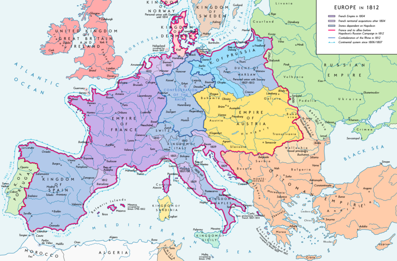
Fichier:Europe 1812 map en.png

Taille de cet aperçu : 800 × 526 pixels. Autres résolutions : 320 × 211 pixels | 640 × 421 pixels | 1 024 × 674 pixels | 1 280 × 842 pixels | 2 284 × 1 503 pixels.
Fichier d’origine (2 284 × 1 503 pixels, taille du fichier : 1,14 Mio, type MIME : image/png)
Historique du fichier
Cliquer sur une date et heure pour voir le fichier tel qu'il était à ce moment-là.
| Date et heure | Vignette | Dimensions | Utilisateur | Commentaire | |
|---|---|---|---|---|---|
| actuel | 11 septembre 2016 à 16:26 |  | 2 284 × 1 503 (1,14 Mio) | KaterBegemot | Border corrections at Thorn and Tarnopol area, minor kerning and positioning changes |
| 20 juillet 2016 à 01:47 |  | 2 284 × 1 503 (1,14 Mio) | KaterBegemot | Added Bukovina / Corrected spelling of Sevastopol, Courland, Belgrade, Duchy of Warsaw / Marked Corfu as territory under French influence (red) / Correct position of city points of Basel, Geneva, Toulouse / Minor border corrections / Better kerning / T... | |
| 14 juillet 2016 à 01:21 |  | 2 284 × 1 503 (1,14 Mio) | KaterBegemot | Added P. of Neuchatel, Ekaterinoslav, Varna, Brăila / Corrected borders of Montenegro, Milan-Genoa area | |
| 3 décembre 2015 à 01:43 |  | 2 284 × 1 503 (1,09 Mio) | Ras67 | frame cropped | |
| 29 novembre 2015 à 12:31 |  | 2 293 × 1 512 (1,12 Mio) | Spiridon Ion Cepleanu | Some details & corrections in the Austrian & Ottoman empires, according with « Grosser Atlas zur Weltgeschichte » (H.E.Stier, dir.) Westermann 1985, ISBN 3-14-100919-8, « Putzger historischer Weltatlas Cornelsen » 1990, ISBN 3-464-00176-8, « Atlas... | |
| 5 octobre 2013 à 22:47 |  | 2 293 × 1 512 (1,01 Mio) | KaterBegemot | Corrected boundaries of Switzerland, Prussia and Circassia | |
| 16 septembre 2012 à 00:53 |  | 2 293 × 1 512 (1,01 Mio) | KaterBegemot | == {{int:filedesc}} == {{Information |Description= {{de|1=Europa 1812. Politische Ausgangslage vor Napeoleons Russlandfelzug.}}{{en|1=Europe in 1812. Political situation before Napoleon's Russian Campaign.}} |Source={{Own}}. Source of Information: </br... |
Utilisation du fichier
Les 5 pages suivantes utilisent ce fichier :
Usage global du fichier
Les autres wikis suivants utilisent ce fichier :
- Utilisation sur af.wikipedia.org
- Utilisation sur azb.wikipedia.org
- Utilisation sur be-tarask.wikipedia.org
- Utilisation sur bn.wikipedia.org
- Utilisation sur bn.wikibooks.org
- Utilisation sur br.wikipedia.org
- Utilisation sur ca.wikipedia.org
- Utilisation sur ce.wikipedia.org
- Utilisation sur cs.wikipedia.org
- Utilisation sur da.wikipedia.org
- Utilisation sur de.wikipedia.org
- Utilisation sur el.wikipedia.org
- Utilisation sur en.wikipedia.org
- History of Austria
- Napoleonic Wars
- Puppet state
- Napoleon
- Client state
- Klemens von Metternich
- France in the long nineteenth century
- Ideas of European unity before 1948
- Principality of Erfurt
- First French Empire
- Territorial evolution of France
- French invasion of Russia
- Alexander I of Russia
- Wikipedia talk:GLAM/Israel Museum, Jerusalem
- French period
- History of French foreign relations
- List of French client states
- International relations (1648–1814)
- Conference of Dresden (1812)
- User:Falcaorib/Europe
- Utilisation sur en.wikibooks.org
- Utilisation sur eo.wikipedia.org
- Utilisation sur es.wikipedia.org
- Utilisation sur fi.wikipedia.org
- Utilisation sur fy.wikipedia.org
- Utilisation sur hr.wikipedia.org
- Utilisation sur hu.wikipedia.org
Voir davantage sur l’utilisation globale de ce fichier.


