Fichier:Bonne projection of world with grid.png
Pas de plus haute résolution disponible.
Bonne_projection_of_world_with_grid.png (295 × 275 pixels, taille du fichier : 69 kio, type MIME : image/png)
Ce fichier et sa description proviennent de Wikimedia Commons.
Description
| Description |
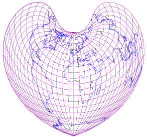
English: world map in Bonne projection with 10-degree grids, only in black lines on white background |
||
| Date | |||
| Source | drawn by myself; using freely available materials especially DCL found at http://www.gfd-dennou.org/arch/dcl | ||
| Auteur | prasinos | ||
| Autorisation (Réutilisation de ce fichier) |
public domain | ||
| Autres versions |
|

Conditions d’utilisation
| Moi, propriétaire des droits d’auteur sur cette œuvre, la place dans le domaine public. Ceci s'applique dans le monde entier. Dans certains pays, ceci peut ne pas être possible ; dans ce cas : J’accorde à toute personne le droit d’utiliser cette œuvre dans n’importe quel but, sans aucune condition, sauf celles requises par la loi. |
Historique du fichier
Cliquer sur une date et heure pour voir le fichier tel qu'il était à ce moment-là.
| Date et heure | Vignette | Dimensions | Utilisateur | Commentaire | |
|---|---|---|---|---|---|
| actuel | 14 octobre 2007 à 21:00 | | 295 × 275 (69 kio) | Prasinos | {{Information |Description=world map in Bonne projection with 10-degree grids, blue continents and purple grauticle on white background |Source=drawn by myself with program http://apollo.ersc.wisc.edu/finch/zz2007/cartoplus/dcl-projfigs.shar using freely |
| 30 septembre 2007 à 22:14 |  | 295 × 275 (28 kio) | Prasinos | {{Information |Description=world map in Bonne projection with 10-degree grids, only in black lines on white background |Source=drawn by myself; using freely available materials especially DCL found at http://www.gfd-dennou.org/arch/dcl |Date=2007-10-01 |A |
Utilisation du fichier
Les 4 pages suivantes utilisent ce fichier :
Usage global du fichier
Les autres wikis suivants utilisent ce fichier :
- Utilisation sur oc.wikipedia.org
- Utilisation sur pt.wikipedia.org