Fichier:Anatolia1300.png
Pas de plus haute résolution disponible.
Anatolia1300.png (535 × 330 pixels, taille du fichier : 81 kio, type MIME : image/png)
Ce fichier et sa description proviennent de Wikimedia Commons.
Description
| Description |
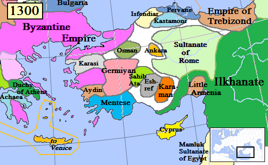
English: Map of the Anatolia region in AD 1300.
(Partially based on Euratlas map of Europe, 1300.) |
| Date | |
| Source | Travail personnel |
| Auteur | Gabagool |
| Autres versions |
.png)
Conditions d’utilisation
Moi, en tant que détenteur des droits d’auteur sur cette œuvre, je la publie sous la licence suivante :
Ce fichier est disponible selon les termes de la licence Creative Commons Attribution 3.0 Non transposée.
- Vous êtes libre :
- de partager – de copier, distribuer et transmettre cette œuvre
- d’adapter – de modifier cette œuvre
- Sous les conditions suivantes :
- paternité – Vous devez donner les informations appropriées concernant l'auteur, fournir un lien vers la licence et indiquer si des modifications ont été faites. Vous pouvez faire cela par tout moyen raisonnable, mais en aucune façon suggérant que l’auteur vous soutient ou approuve l’utilisation que vous en faites.
Historique du fichier
Cliquer sur une date et heure pour voir le fichier tel qu'il était à ce moment-là.
| Date et heure | Vignette | Dimensions | Utilisateur | Commentaire | |
|---|---|---|---|---|---|
| actuel | 20 janvier 2017 à 18:46 | | 535 × 330 (81 kio) | Cplakidas | fixing Dodecanese: Menteshe never controlled the offshore islands; they remained Byzantine until the Hospitallers or Genoese of Chios took them. |
| 18 avril 2009 à 00:26 |  | 535 × 330 (64 kio) | Gabagool | Byzantine color lighter. New Armenia -> Little Armenia | |
| 2 avril 2009 à 21:12 |  | 535 × 330 (64 kio) | Gabagool | added mamluks | |
| 31 mars 2009 à 18:36 |  | 535 × 330 (63 kio) | Gabagool | {{Information |Description={{en|1=Map of the Anatolia region in AD 1300. (Partially based on Euratlas map of Europe, 1300.)}} |Source=Own work by uploader |Author=Gabagool |Date=2009-03-31 |Permission= |other_versions= }} <!--{{ImageUp |
Utilisation du fichier
La page suivante utilise ce fichier :
Usage global du fichier
Les autres wikis suivants utilisent ce fichier :
- Utilisation sur als.wikipedia.org
- Utilisation sur ar.wikipedia.org
- Utilisation sur arz.wikipedia.org
- Utilisation sur azb.wikipedia.org
- Utilisation sur az.wikipedia.org
- Utilisation sur ba.wikipedia.org
- Utilisation sur bg.wikipedia.org
- Utilisation sur bn.wikipedia.org
- Utilisation sur ca.wikipedia.org
- Utilisation sur cs.wikipedia.org
- Utilisation sur de.wikipedia.org
- Utilisation sur el.wikipedia.org
- Utilisation sur en.wikipedia.org
Voir davantage sur l’utilisation globale de ce fichier.