Fichier:Map of OIC.png

Taille de cet aperçu : 800 × 400 pixels. Autres résolutions : 320 × 160 pixels | 640 × 320 pixels | 1 250 × 625 pixels.
Fichier d’origine (1 250 × 625 pixels, taille du fichier : 40 kio, type MIME : image/png)
Ce fichier et sa description proviennent de Wikimedia Commons.
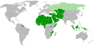
| Description | Members of OIC |
| Date | |
| Source | Travail personnel |
| Auteur | Myrzic Cyril |
| Ce document n'est pas soumis au droit d'auteur et est donc dans le domaine public, car il est composé exclusivement d'informations qui sont dans le domaine public et ne contient aucune modification qui en ferait une œuvre originale. |
Historique du fichier
Cliquer sur une date et heure pour voir le fichier tel qu'il était à ce moment-là.
| Date et heure | Vignette | Dimensions | Utilisateur | Commentaire | |
|---|---|---|---|---|---|
| actuel | 2 février 2018 à 22:31 | | 1 250 × 625 (40 kio) | Maphobbyist | Check |
| 2 février 2018 à 22:26 |  | 1 250 × 625 (40 kio) | Maphobbyist | Added borders of South Sudan which became idependent in 2011 and which is not a member of the OIC. | |
| 27 août 2008 à 15:31 |  | 1 250 × 625 (55 kio) | Myrzich Cyril | {{Information |Description= |Source= |Date= |Author= |Permission= |other_versions= }} | |
| 26 mai 2008 à 14:53 |  | 1 250 × 625 (55 kio) | Myrzich Cyril | {{Information |Description= Members of OIC |Source= Собственная работа |Date= may 26, 2008 |Author= Myrzich Cyril |Permission= |other_versions= }} {{PD-ineligible}} Category:Subcontinental maps | |
| 26 mai 2008 à 14:31 |  | 1 250 × 625 (55 kio) | Myrzich Cyril | {{Information |Description= Members of OIC |Source= Собственная работа |Date= may 26, 2008 |Author= Myrzic Cyril |Permission= |other_versions= }} {{PD-ineligible}} Category:Subcontinental maps |
Utilisation du fichier
La page suivante utilise ce fichier :
Usage global du fichier
Les autres wikis suivants utilisent ce fichier :
- Utilisation sur be.wikipedia.org
- Utilisation sur en.wikipedia.org
- Utilisation sur es.wikipedia.org
- Utilisation sur fa.wikipedia.org
- Utilisation sur he.wikipedia.org
- Utilisation sur it.wikipedia.org
- Utilisation sur uk.wikipedia.org